


Aravalli Hills and Range: Myths Versus Facts Behind the New Legal Definition
The Supreme Court recently clarified the legal status of the Aravalli Hills and Range. This landmark ruling ends decades of geographical ambiguity. Consequently, it creates a unified framework for conservation across four Indian states.
Defining the Aravalli Hills and Range
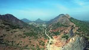
The court now recognizes two distinct definitions. First, an Aravalli Hill is any landform rising 100 meters above the local relief. This includes the entire hill, its slopes, and all associated geological features.
Second, the Aravalli Range consists of two or more hills within 500 meters of each other. Furthermore, the definition includes the intervening areas. Experts use “buffer intersection analysis” to map these connected ecological corridors accurately.
Who Created the New Standards?
On November 20, 2025, the Supreme Court adopted these definitions in a formal judgment. Initially, a high-level committee recommended these specific metrics. This committee included officials from the Ministry of Environment, Forest and Climate Change (MoEF&CC).
While the government proposed the criteria, the Court made them legally binding. Therefore, these standards now carry the full weight of the law across Delhi, Haryana, Rajasthan, and Gujarat.
Why Was a New Definition Necessary?
Previously, the lack of a uniform definition hindered environmental protection. It allowed rampant illegal mining and accelerated ecological degradation. Moreover, the Aravallis serve as a vital “green barrier” against the Thar Desert’s expansion.
This legal shift addresses India’s commitment to the UN Convention to Combat Desertification. Specifically, it resolves issues raised in long-standing PILs like the M.C. Mehta case. A unified definition ensures that mining regulation remains scientific and sustainable.
The Source of the Standard
Interestingly, the new criteria are not entirely new. They originate from Rajasthan’s existing 2002 guidelines and Richard Murphy’s 1968 landform classifications. Rajasthan has successfully followed this 100-meter rule since 2006. Now, the rest of the range must follow suit.
Future of Mining in the Aravallis
The Court directed the MoEF&CC to create a Management Plan for Sustainable Mining (MPSM). This plan will identify which areas are strictly off-limits. Importantly, no new mining leases will be granted until this plan is finalized.
“The objective is to identify conservation-critical areas where mining shall be strictly prohibited.”
Debunking the “90 Percent” Myth
Social media claims suggest that 90% of the range is now open to mining. However, this is factually incorrect. The 500-meter proximity rule protects many lower landforms. Additionally, existing Tiger Reserves and wildlife sanctuaries remains strictly protected.
The upcoming MPSM will conduct district-level studies to ensure ecological safety. Thus, the Aravallis remain protected by a complex layer of technical and environmental safeguards.

Prerna Varshney is a journalist and social commentator with over five years of experience in health, gender, and policy reporting. Her work reflects a deep commitment to truth and empathy, simplifying complex issues for everyday readers.