





Nepal Floods: Why Are They Occurring? The Growing Role of Climate Change
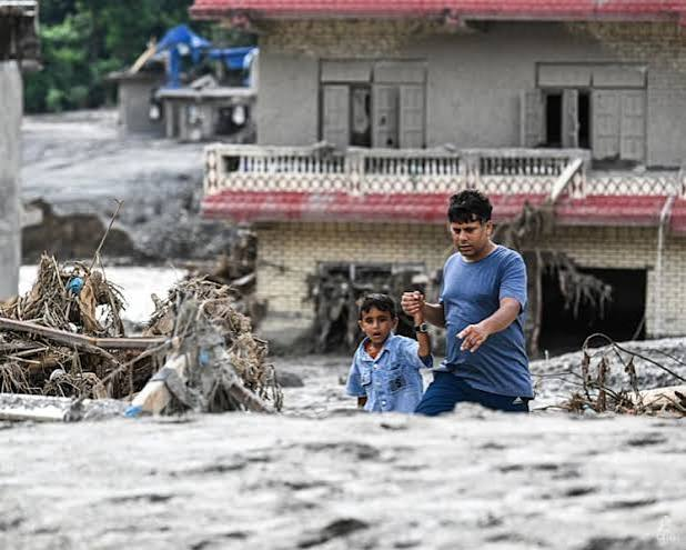
Nepal, a Himalayan country shaped by some of the world’s highest mountains and major river systems, has always experienced floods, landslides and flash floods. However, the nature of these disasters is changing. Increasingly erratic rainfall, intense monsoon downpours, melting glaciers, unstable mountain slopes and rapid development in vulnerable areas are combining to make floods more destructive.
It would therefore be inaccurate to say that every flood in Nepal is caused by climate change. Floods have natural causes, particularly the South Asian monsoon and Nepal’s steep topography. But climate change is increasingly acting as a risk multiplier: it can make extreme rainfall more intense, accelerate changes in glaciers and snow, destabilise mountain terrain and increase the likelihood of compound disasters. The International Centre for Integrated Mountain Development (ICIMOD) identifies Nepal as highly vulnerable to floods, landslides and glacial lake outburst floods, with climate change aggravating these.
A country naturally vulnerable to floods
Nepal’s geography is fundamental to understanding its flood problem.
The country rises dramatically from the low-lying Terai plains to the high Himalayas over a relatively short horizontal distance. Numerous rivers—including the Koshi, Gandaki and Karnali systems—flow southward from the mountains towards the plains.During the summer monsoon, large quantities of moisture enter South Asia. Heavy rainfall falls on Nepal’s steep mountains, rapidly generating surface runoff. Rivers can rise very quickly, while saturated slopes become vulnerable to landslides.
This means that Nepal has always been exposed to water-related disasters. Historical evidence shows that excessive rainfall, glacial-lake outbursts and landslide-dammed rivers have all produced floods. H
The crucial question, therefore, is not whether climate change created Nepal’s flood risk. It is whether climate change is changing the intensity, frequency and geographical reach of existing hazards.
The evidence increasingly suggests that it is.
1. Climate change is making extreme rainfall more dangerous
One of the most important links between climate change and flooding is the warming atmosphere.
A warmer atmosphere can hold more water vapour. When atmospheric conditions produce rainfall, this additional moisture can contribute to more intense precipitation over short periods.
This distinction is important. Climate change does not necessarily mean that Nepal will simply receive more rain every year. Instead, rainfall can become more erratic—with longer dry periods interrupted by exceptionally heavy rainfall.
Dry period → sudden extreme rainfall → rapid runoff → flash flood → landslide/debris flow
Consequently, even a monsoon that is not unusually wet overall can still produce catastrophic flooding if rainfall is concentrated into a few extreme events. ICIMOD previously highlighted this problem after major flooding in Nepal occurred despite expectations of an average-to-below-average monsoon.
2. The Himalayan cryosphere is changing
Nepal’s glaciers are another major part of the story.
The Himalayas are warming rapidly. As temperatures rise, glaciers retreat and lose mass. Melting ice also contributes to the expansion of glacial lakes behind natural dams made of rock and debris.
These lakes can become extremely dangerous.
If a natural moraine dam fails, enormous quantities of water can suddenly rush downstream. This phenomenon is known as a Glacial Lake Outburst Flood (GLOF).
ICIMOD has identified potentially dangerous glacial lakes in the Koshi, Gandaki and Karnali river basins.
Climate change does not mean that every glacier will suddenly release a flood. Rather, warming changes the conditions under which glaciers, ice, snow and mountain slopes exist. It can therefore increase the background risk of cascading hazards.
3. Climate change can destabilise mountain slopes
Nepal’s problem is not simply “too much water.”
It is also unstable mountains + water + warming.
Heavy rainfall can saturate soil and weaken slopes, triggering landslides. Those landslides can block rivers and temporarily create natural dams. If such a dam collapses, the resulting flood can travel downstream with enormous destructive power.
Warming can add another layer of instability. Changes in the freezing and thawing of water within rocks, snow and ice can affect high-altitude slopes. Glacier retreat can also remove ice that previously contributed to the stability of mountain terrain.
This produces what scientists increasingly describe as compound or cascading hazards:
warming → glacier/snow change → unstable slope → landslide or ice-rock avalanche → river blockage or sudden water release → flash flood → downstream destruction
The 2026 disaster on the Nepal–Tibet border provides a dramatic example of why this matters.
4. The 2026 Himalayan disaster: a warning from the mountains
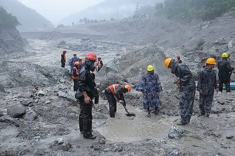
In August 2026, a catastrophic flash flood struck the Nepal–China Himalayan border after an enormous mass of ice, rock and mud entered the Lhende Khola river system. Scientists said the immediate trigger was still being investigated, with an earthquake considered a possible trigger, while observations also suggested recent warmth and snow/ice melt may have contributed to unstable conditions. RReuters+1
This distinction is scientifically important.
It would be wrong to claim:
“Climate change caused the 2026 flood.”
The immediate trigger may have been geological—a collapse or avalanche, potentially associated with an earthquake.
But climate change can alter the conditions in which such an event occurs.
Scientists cited by Reuters explained that warming can destabilise high-mountain ice and rock by changing melting, freezing and thawing processes. Nepal’s mountain regions have also experienced substantial ice loss over recent decades. RReuters+1
Thus, the 2026 disaster illustrates an important principle of climate science:
Climate change does not have to be the immediate trigger to make a disaster more likely or more severe.
5. Human activities are turning hazards into disasters
Climate change is only part of the explanation.
A natural hazard becomes a disaster when it encounters vulnerable people, infrastructure and settlements.
Nepal has experienced rapid development of roads, hydropower projects, settlements and other infrastructure in mountainous and riverine environments. When roads are constructed across unstable slopes, vegetation is removed or construction takes place too close to rivers, natural hazards can cause much greater damage.
Floodplains are particularly important. Rivers naturally need space to expand during extreme floods. When houses, roads and other infrastructure occupy these areas, even a relatively predictable flood can become a humanitarian disaster.
Hydropower development creates another dilemma. Nepal possesses enormous hydropower potential, and hydropower is strategically important to its economy. But infrastructure located in steep valleys and river corridors can be exposed to floods, landslides and debris flows.
The recent 2026 floods demonstrated this vulnerability dramatically: Reuters reported that hundreds of megawatts of Nepal’s electricity-generating capacity were damaged, illustrating the vulnerability of energy infrastructure to increasingly complex climate and geological hazards. RReuters
The lesson is not that Nepal should stop developing hydropower. Rather, future infrastructure must be designed for future climate and geological risks—not simply for historical conditions.
6. Deforestation and land-use change can worsen flooding
Vegetation plays an important role in controlling runoff.
Forests and healthy soils can intercept rainfall, increase infiltration and reduce the speed at which water reaches rivers. When vegetation is removed and soil is disturbed, rainfall can generate greater surface runoff and erosion.
In mountainous Nepal, this can contribute to sedimentation and landslides.
However, it is important not to oversimplify this relationship. Forest cover is only one factor among many. Extreme rainfall, geology, slope, river morphology and land-use practices all interact.
Therefore, blaming Nepal’s floods solely on deforestation would be just as misleading as blaming them solely on climate change.
7. Why the Terai is especially vulnerable
The consequences of flooding extend far beyond the Himalayas.
Rivers originating in Nepal eventually flow into the densely populated plains of southern Nepal and northern India. The Terai is relatively flat, heavily populated and agriculturally important.
When Himalayan rivers carry huge quantities of water and sediment downstream, flood risk can increase in these lowland areas.
This creates a mountain-to-plains chain of vulnerability:
Himalayan rainfall and snow/glacier changes → mountain runoff and landslides → swollen rivers → Terai flooding → agricultural and economic losses
This also demonstrates why flood management cannot be treated as a purely local issue. Nepal’s rivers cross national boundaries, making cooperation with India and China important for forecasting, data sharing and disaster preparedness.
The deeper problem: old assumptions are becoming unreliable
For decades, infrastructure and disaster planning have relied heavily on historical weather patterns.
But climate change challenges that approach.
If the climate is changing, yesterday’s “100-year flood” may not represent tomorrow’s risk. Infrastructure designed according to historical rainfall and river behaviour may therefore prove inadequate.
Nepal therefore faces a difficult planning problem: it must build infrastructure today while anticipating a climate that may be considerably different from the one in which existing infrastructure was designed.
What should Nepal do?
Nepal cannot prevent the monsoon or stop climate change by itself. But it can substantially reduce disaster losses.
1. Strengthen early-warning systems
Flood forecasting, rainfall monitoring, satellite observation and community warning systems can save lives.
Warnings must reach people before, not during, the flood.
2. Monitor glaciers and glacial lakes
High-risk glacial lakes should be continuously monitored. Where necessary, engineering measures can reduce lake levels or strengthen vulnerable structures.
3. Climate-proof infrastructure
Roads, bridges, hydropower plants, settlements and transmission lines need to be assessed against future—not merely historical—flood and landslide risks.
4. Improve cross-border data sharing
Because Himalayan rivers cross borders, Nepal needs rapid access to rainfall, river-level, glacier and hazard information from neighbouring countries.
The 2026 disaster has renewed attention to the importance of data sharing and real-time warning systems between Nepal and China.
5. Protect watersheds
Reforestation, sustainable land management and protection of wetlands and river corridors can help reduce erosion and runoff in vulnerable locations.
6. Restrict construction in high-risk zones
Disaster resilience cannot depend entirely on engineering. Sometimes the safest strategy is simply not to build in a dangerous location.
Nepal’s floods are not a new phenomenon, and it would be scientifically incorrect to attribute every flood directly to climate change. The country’s steep Himalayan geography, monsoon climate, unstable geology and extensive river networks naturally create substantial flood risk.
Rising temperatures are altering glaciers, snow and high-altitude environments. Extreme rainfall can become more intense and erratic. Mountain slopes can become increasingly vulnerable to combinations of rainfall, melting ice, landslides and geological disturbances. At the same time, population growth, infrastructure development and settlement in hazardous areas are increasing exposure.
The result is a dangerous equation:
Climate change + Himalayan fragility + extreme rainfall + glacier change + human exposure = rising flood risk.
The most important lesson from Nepal is therefore not simply that “climate change causes floods.” The more accurate conclusion is that climate change is amplifying an already dangerous natural system.
Nepal’s future flood strategy must consequently combine climate adaptation, scientific monitoring, resilient infrastructure, responsible land-use planning, early-warning systems and regional cooperation. As the Himalayas warm, preparing for a more uncertain and potentially more extreme water cycle is no longer optional—it is essential for protecting Nepal’s people, economy and infrastructure.

NewsHasghag operates a 24/7 news bureau that tracks the real-time, social media-driven stories from India and around the world, keeping you ahead of the day’s key talking points. Our digital-first approach transforms storytelling through the seamless integration of data, interactive charts, video, and audio into every narrative